
The spelling of the township name of Tarbock, named after a local brook, has changed more than any other in the West Derby Hundred. Variations have included Tarboc (1086), Turboc (1245), Terbock (1327), Tarbacke (1637) and Torbock before settling on its current form in the late seventeenth century. The township itself is 6 miles from Liverpool, 3.5 miles from Widnes and 2 miles from Prescot.
The Domesday Survey noted that the manor of ‘Tarboc’ was one of those previously held by the Saxon Thane, Dot. Tarboc, along with ‘Hitune’ (Huyton) was granted to Henry II in 1150 before it was given to the Lathom family. Towards the end of the twelfth century, the two were split between different branches of the family with Tarbock being assigned to Henry de Lathom. His son Richard was the first to adopt the name ‘de Torbock’.

Lancashire Archives ref: DRL 1-78
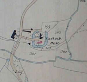
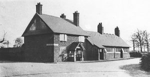
Tarbock Hall features in Saxton’s map of Lancashire in 1577, although parts of the hall are believed to be fifteenth century in origin. It was surrounded by a ‘moat’ which was still very prominent on the Tithe map produced in 1847, although three-sides were reported to have been filled-in by the turn of that century. Ownership of the manor remained in the Lathom family, often through the female line, until 1611 when it was sold to Thomas Sutton, a London gentleman and founder of Charterhouse School. Unfortunately Sutton died a few months later and it was his nephew who sold the estate to Sir Richard Molyneux, the Earl of Sefton three years later for £10,500.
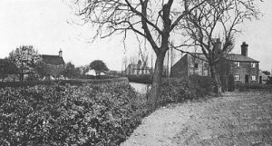
The oldest part of the township is the area around the hamlet of Tarbock Green, often called Blue Duck corner named after a former inn.
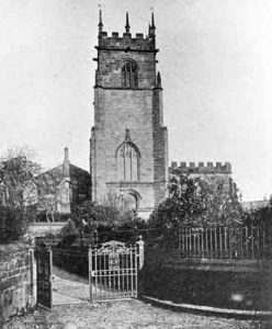
In the fourteenth century Tarbock Hall had its own private chapel but Tarbock’s villagers would have attended St. Michael’s Church at Huyton.
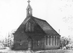
It is thought that a chapel was built at Tarbock Green in the mid sixteenth century. The building was pulled down in the late 1830s, despite being ‘rich in carved woodwork’ (possibly due to the completion of a Chapel of Ease at Halewood in 1839).
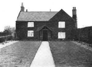
This area which is now an important conservation area contains a number of old cottages, including one, believed to be the oldest in the village, which bears a datestone of 1776.
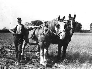
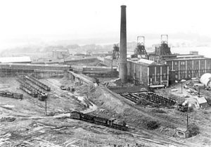
In the sixteenth century, the manor is described as having two watermills, a windmill and a fulling mill. When the Earl of Sefton conducted a survey of his Estates in 1769, there was both a watermill and a windmill still in use. Even in the early twentieth century the township remained predominantly rural until the opening of a new coalmine at Halsnead Park.
The coal mine that bordered the townships of Cronton, Tarbock and Whiston was originally called Hulton Colliery but is more widely known by its later name of Cronton Colliery (although the main entrance to it was actually in Tarbock). This colliery had a huge impact on the local community as many workers left the land to work in the mine.
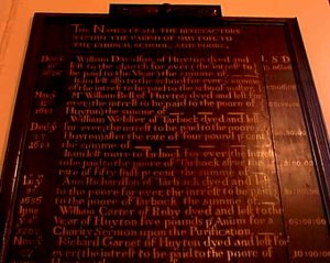
William Webster, who died in 1684, bequeathed the interest of some shares he held for the poor of both Huyton and Tarbock. Known as Webster’s Dole, this legacy survived for nearly three hundred years.
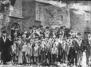
Another example of local charity is that of the Oddfellows. This group established a lodge in Prescot in 1827 and became very active in the area. In Tarbock during the late 1830s, three separate lodges were founded, although two did quickly disband due to lack of members. The Loyal Farmers Rest Lodge was more successful and held regular meetings in the Brick Wall Inn. Each July, to mark their foundation day, they would march along Greensbridge Road to Halewood.
Improved communications came in the late 1720s with the Liverpool-Warrington Turnpike passing through the township. Although it doesn’t appear to have had the same impact it did in other townships it passed through. In the mid 1770s a canal to link the River Mersey with the Sankey canal was proposed. This route would have gone via Halewood, Cronton and Tarbock but was opposed by the Earl of Derby and the Earl of Sefton as being unnecessary and after a few years the scheme was dropped.
In the late nineteenth century there seems to have been a phase of re-development, albeit on a small scale with the post office and smithy building which was originally thatched, being rebuilt in 1884.
In 1890 a large pavilion was built alongside the Brick Wall Inn and was an important centre for social and community events until it was demolished in 1940 as part of the complete re-building of the Brick Wall Inn site.
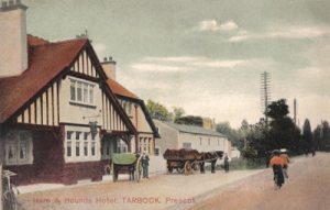
Of far more significance, was the sale of the Tarbock Estate by a public auction in 1926 at the local Hare and Hounds Hotel. The sale catalogue that was produced for the event provides a detailed insight into the various properties, their value and their tenants, many of whom bought the property they lived in. The Estate measured nearly 2300 acres and featured twenty farms, including Georgeson’s Farm and Wood Lane Farm and over fifty houses and cottages.

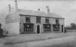
The original Brick Wall Inn was a plain square building built using handmade bricks and over a period of years a number of outbuildings including a shippon and stables were added. For over a century the licence was held by the Ambrose family. Until the 1880s, the ale sold was that brewed by Fleetwood’s at Brewery House on the opposite side of the road. In 1920s, the brewery was bought by the Burtonwood Brewery Company.
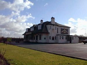
A new larger Brickwall Inn was opened in 1940, built just behind the earlier inn which was soon after demolished. This replacement public house closed around 2006 and the building remained vacant until 2012 when it was turned into a high-class cattery called Pets Country Manor. The only surviving public house in the Tarbock township is now the Hare and Hounds on Cronton Road.
In recent times, the township has increased in prominence through its proximity to the Tarbock Interchange. This roundabout, believed to be the largest in Europe with a circumference of a mile, connects M62 (at Junction 6), M57 (at Junction 1), A5080, A5300 and Windy Arbor Road.
Following public consultation, plans were approved in August 2018, for a major retail development on vacant land situated between Cronton Road and M62 Motorway. On the land, accessed by Coppice Lane, a new ALDI supermarket was proposed, together with some smaller business premises. The project also featured changes to the traffic flow by the installation of a new set of traffic lights controlling the movement on Cronton Road, Wilson Road and Coppice Lane.
By August 2019, groundworks and highways work had begun on the Cronton Road development and by early 2020 the proposed new traffic lights were in operation, successfully easing what was once a congested junction.
The Coronavirus pandemic in 2020 dominated the news for the whole year. A timeline of the events that occurred can be consulted here: COVID-19 National and Local timeline 2020
On 10th September 2020, the new ALDI supermarket adjacent to Coppice Lane, off Cronton Road opened for business followed a year later by the opening of the new Coppice Lane Services comprising a Shell Service Station, Asda, Greggs, KFC and Starbucks outlets.
As the Coronavirus pandemic continued in 2021 with new variants appearing, a further timeline shows the changing situation throughout the year: COVID-19 National and Local timeline 2021
The success of the UK’s vaccination programme meant that coronavirus restrictions were eased in 2022. A summary of COVID-19 information for the year can be found here: COVID-19 National and Local timeline 2022
The UK Government’s Emergency Alerts System is now live and will be used to warn people when lives are in danger, initially to warn of severe weather-related incidents including flooding and provide instructions how to respond to an alert. To check the system, a test took place at 3pm on Sunday 23rd April whereby most people received an official text message on their mobile phones.
The latest COVID-19 information can be found here: COVID-19 National and Local timeline 2023 (to end of May 2023)